
Sediment Transport and Geomorphology
This topic addresses the passage of sediment — particularly fine sediment and the nutrients it carries — through and past the dam, so that downstream reaches and the Mekong Delta remain sustainable.
Download this section (PDF)
Key objectives
- Maintain the downstream transport of sediment and nutrients as far as practicable.
- Provide for sediment management — flushing, sluicing and density-current venting — through appropriately sized low-level outlets.
- Avoid long-term reservoir sedimentation and downstream channel and delta degradation.
What the guidance addresses
The guidance covers sediment-passage facilities, flushing and sluicing operations, low-level outlet design, and sediment monitoring, in support of a sustainable sediment budget for the basin.
74. The objectives for sediment transport and geomorphology are as follows:
- Maintain the morphological equilibrium of the Mekong River.
- Minimize changes to sediment delivery to the downstream environment with respect to sediment quantity, the seasonality of sediment delivery, and grain-size composition of the sediment load.
- Minimize geomorphic impacts arising from changes in sediment transport, including changes to river banks, river beds and aquatic and riparian habitats.
- Minimize deposition within and downstream of the impoundment to prevent upstream river changes, and maintain and protect project infrastructure.
75. There are no MRC Procedures that directly relate to sediment transport or geomorphology. The importance of sediment transport is recognized by the Member Countries cooperating in the monitoring of sediment movements through the Discharge and Sediment Monitoring Programme (Koehnken, 2014). In addition, the themes of sediment transport and geomorphology are included in the former MRC Water Utilisation Programme, the MRC Initiative for Sustainable Hydropower Studies (MRC, 2014), and in other published MRC studies.
76. Dams interrupt the natural continuity of sediment transport in river systems, inducing deposition within the impoundment, and altering the sediment quantity and composition in water released to the downstream river. These changes have a number of implications for water quality, aquatic ecology, fisheries, navigation, commercial activities and community uses.
77. Potential sediment transport and geomorphic risks should be comprehensively assessed. Risks associated with sediment transport and geomorphic risks associated with hydropower development are summarised in Table 3.1.
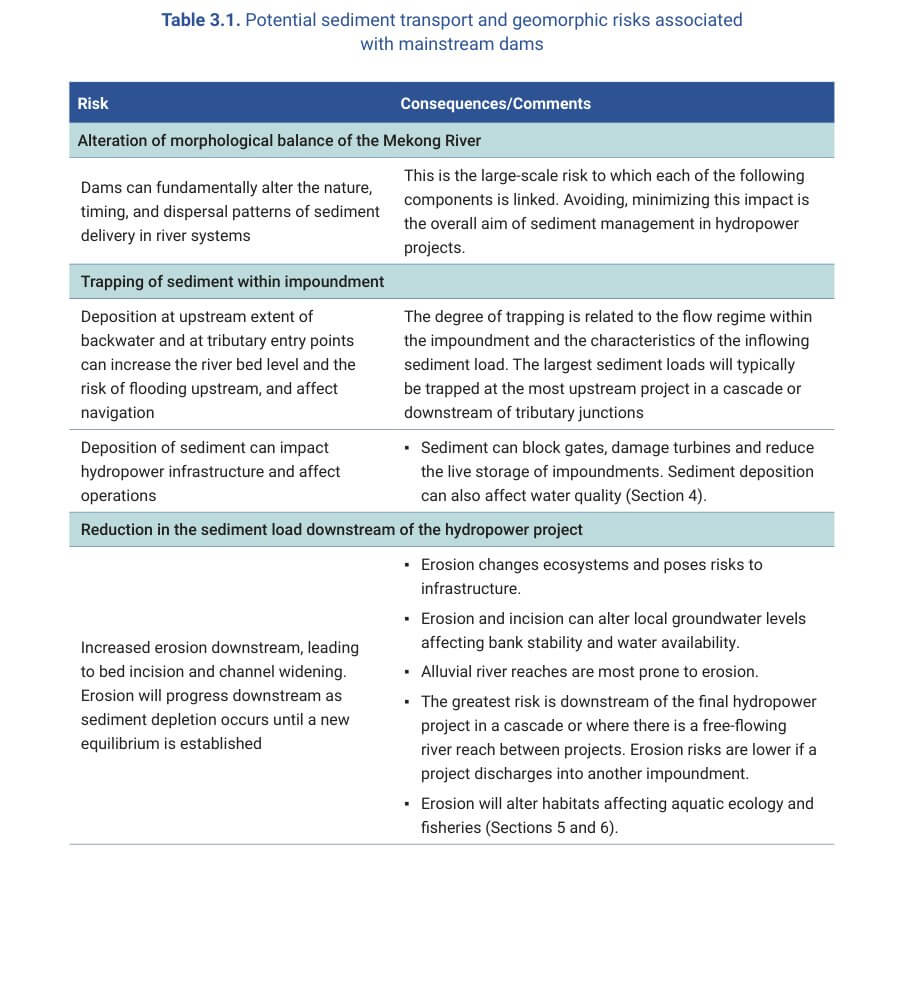
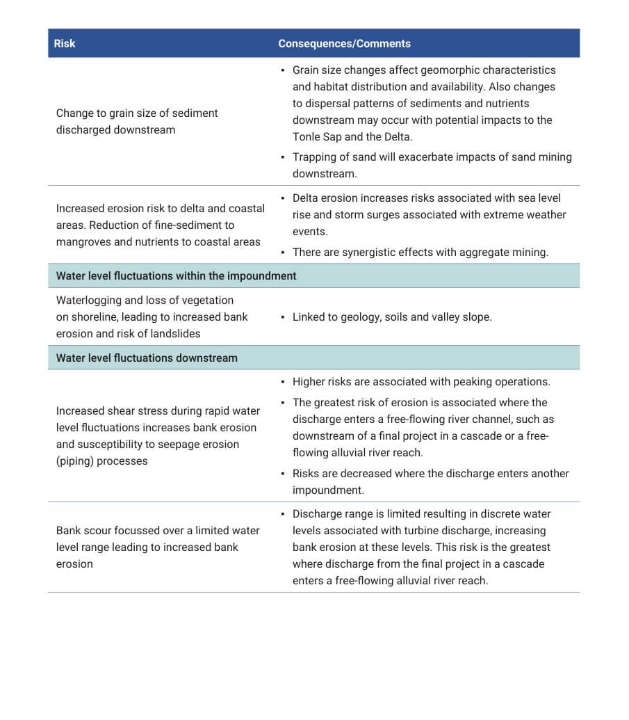
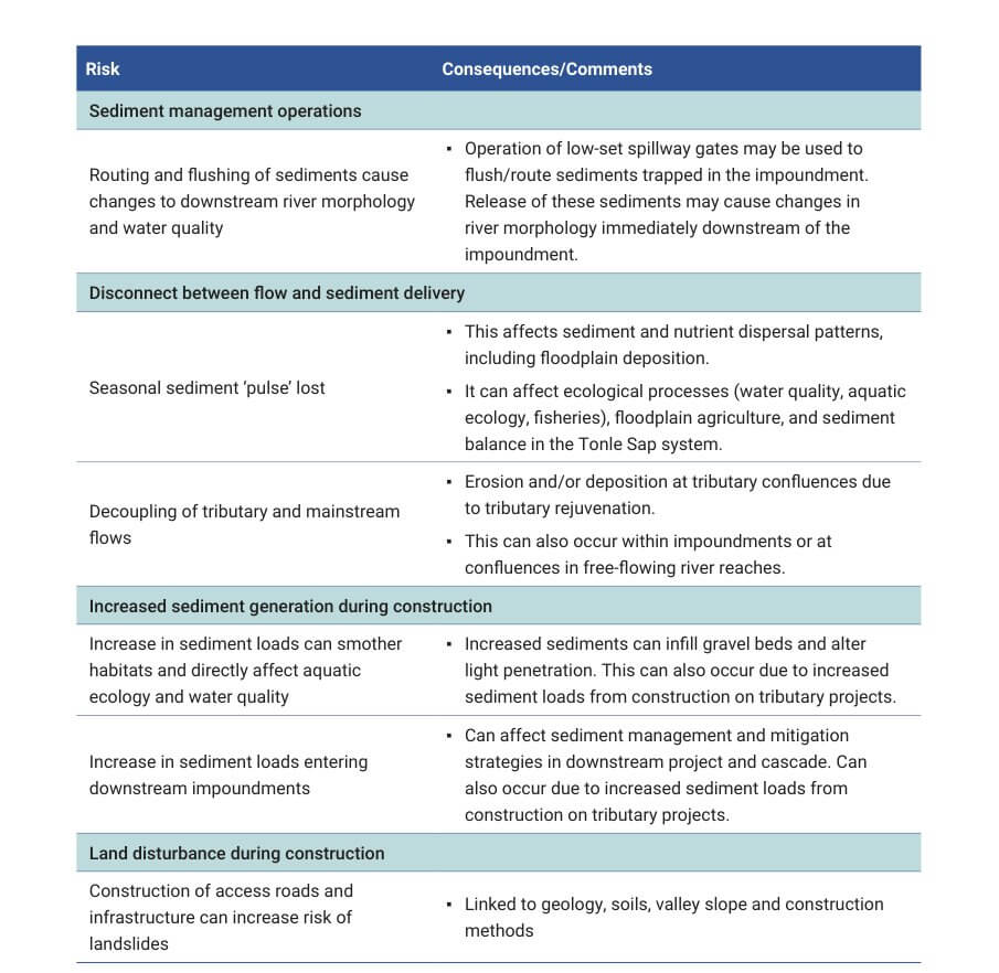
78. The location of a project within a cascade and the location relative to tributary projects should be considered when identifying risks. The potential for future mainstream or tributary developments to alter conditions and risks should also be considered.
79. The information submitted for the PNPCA process should demonstrate quantification of pre-project conditions and quantitative identification of potential changes for sediment transport and geomorphology, based on a combined monitoring and modelling approach. The information submitted should include:
- site-specific monitoring of sediment transport and geomorphological characteristics at a spatial scale appropriate to the development;
- a basic numerical sediment transport model integrated with the hydrological and hydraulic transport model (see Section 2.3). This model should be capable of quantifying sediment transport and geomorphic changes associated with hydropower operations over suitable geographic ranges and timescales, including demonstrating potential transboundary changes. More than one model may be required to adequately capture the details required near the dam and hydropower infrastructure, and to provide an indication of geomorphic change over long river reaches;
- the numerical modelling may be supplemented by physical modelling during the detailed design stages. Any physical model should be designed with application of relevant scaling laws and assessment and interpretation of relevant hydraulic and sediment parameters (e.g. Froude number, Reynolds values, Shields parameters).
80. The monitoring and modelling should be used to describe and quantify baseline conditions in the project reach and potential project operations, providing:
- a quantitative description of the existing environment with respect to sediment transport and geomorphic characteristics as outlined in Clause 81;
- a basis for identifying and evaluating potential changes to the river due to the development, as outlined in Clause 82;
- a basis for identifying risks as outlined in Section 3.2, and identifying and optimizing mitigation measures as outlined in Section 3.4.
81. The description of the existing environment should include, but not be limited to:
- the annual sediment budget divided into seasons, including an indication of sediment variability and trends associated with other developments (e.g. decreasing sediment supply over time due to upstream mainstream or tributary dams);
- grain-size distribution on a seasonal basis, using the grain-size definitions and nomenclature defined in the Definition of Terms;
- existing geomorphic characteristics and patterns of sediment deposition and erosion in the project area (including the impoundment and downstream);
- a description of the present geomorphic changes occurring associated with existing developments.
82. The description of potential changes to the existing environment associated with the project development should include:
- projected changes to sediment transport5 within and downstream of the impoundment over the life of the project, such as impoundment sedimentation, sediment transport downstream of the dam, and channel changes downstream of the dam;
- an evaluation of how the impacts from the project are likely to change due to future planned upstream or downstream developments by developer and host nation with the support of regional agencies as required, for example, the MRCS;
- a description of the forecast state of impoundment sedimentation, sediment management infrastructure, and downstream physical geomorphic changes at the end of the concession period. This will allow the relevant Member Country to include quality standards, design requirements and operational targets in the Concession Agreement to ensure the value of the asset at the time of relinquishment;
- A description of how adaptive management will be implemented over the concession period and the uncertainties associated with the assessment. Guidance for monitoring
83. The monitoring approach for sediment transport and geomorphology should be shown in the PNPCA information to be sufficient to inform full feasibility level design, to support modelling for impact prediction, and to help with later impact evaluation. Clause 23 provides basic principles to guide design of the overall monitoring network. The following clauses can be used as a guide, and varied to suit project-specific conditions.
84. Monitoring should be completed over a sufficient geographic range to identify potential impacts associated with the development, guided by Clause 20. The number and location of monitoring sites should include:
- the hydrologic monitoring sites described in Section 2.3 such that the pre-project sediment loads entering and discharged from the project area are accurately quantified;
- at an existing MRC sediment and discharge monitoring site to allow comparison of sediment transport monitoring results with the existing long-term data set;
- a site located 50% of the distance between the upstream backwater and the dam site if the impoundment is projected to exceed 40 km in length. Additional monitoring sites 5 The basin-scale information and changes may be investigated through MRC assessments (e.g. through the MRC basin planning). within the future impoundment may be required downstream of the confluence of any tributaries entering within the impoundment reach contributing more than 2% of the Mekong average annual flow as measured upstream of that tributary’s confluence;
- at suitable intervals downstream of the dam site reflecting the site-specific nature of the river reach. Sites upstream of major tributary confluences should be included.
- where the river enters a different hydrogeomorphic zone, if applicable.
85. Monitoring parameters should include:
- river flow and hydraulics, as described in Section 2.3. All sediment transport information should be linked to the hydrologic and hydraulic conditions at the time of sampling, including velocity, discharge and depth.
- suspended sediments determined using a depth-integrated isokinetic method or pointintegrated method (Davis, 2005) or equivalent. An equivalent may include the in-situ measurement of sediment volume and grain size using a laser instrument, provided that a calibration between physical sampling and the laser instrument is completed and included in the baseline information.
- grain-size distribution of suspended sediment using either recognized and referenced laboratory settling techniques, laboratory laser or x-ray techniques, or in-situ determination using a laser instrument.
- bedload movement estimates using the Acoustic Doppler Current Profiler (ADCP) loop method (USGS, 2006) or equivalent.
- grain-size distribution of bedload and bed materials using standard sieve sizes consistent with the grain sizes, as specified in the Definition of Terms.
86. The duration of sediment data collection should enable coverage of the full annual cycle with low and high flows, as well as provide insight into inter-annual variability, which is substantial in the Mekong and should be factored into project design. The project-specific field data should be collected for a period of at least one year. This should occur immediately prior to finalization and submission of PNPCA documentation, and explained in light of longer-term trends by having the monitoring network include one or more long-term monitoring sites. The field data collection should continue through the pre-project period to capture more of the inter-annual variability and be used to inform detailed design.
87. The frequency of data collection should be linked to the seasonal hydrology. This timing will enable integration with the MRC sediment monitoring results and enable interpretation of the data within broader datasets.
- Monitoring for all parameters should be completed on a weekly basis during the wet season (June to October, inclusive), and fortnightly during the transition seasons (May and November) as defined for the Mekong (MRC, 2009a). More frequent monitoring during high flow periods and events is desirable for providing information relevant to sediment routing and flushing.
- During the dry season (December to April), monthly monitoring of suspended sediment load only is recommended.
88. Because sediment dynamics at the project site are part of a large-scale and longer-term process of sediment dynamics in the Mekong River, site-specific data collected by the developer should be related and compared with the MRC sediment monitoring data set, and any substantial differences should be investigated and explained.
Guidance for modelling and analyses
89. Sediment modelling should be consistent with Clause 24, and integrated with hydrological and hydraulic modelling (see Section 2.3). Sediment modelling should include the sediment loads, sediment grain-size distribution and seasonal variability. The baseline conditions of the river should be modelled and calibrated using the monitoring results.
90. Scenarios for impoundment sediment deposition and scour should be developed based on an understanding of factors such as: the extent of the flooded areas of the future impoundment; their seasonal fluctuations; the presence of bedrock outcrops; and the influence of tributaries. Scenarios investigating different Project-Specific Operating Rules related to sediment management, such as minimizing deposition in the impoundment backwater, sediment flushing, or sediment routing, should be included.
91. The sediment model should demonstrate the influence of the daily and annual operating pattern of the project on the following:
- the volume and grain-size distribution of deposition in the impoundment, including headwater deposits. Model runs should include impacts from upstream projects where applicable;
- the quantity and grain-size characteristics of the sediment load discharged downstream;
- the downstream river channel adjustments attributable to the change in sediment transport, and the extent of downstream influence of the project operations based on water level fluctuations. Changes to the river thalweg, channel shape, sand and gravel bars, and deep pools should be identified. A discussion of model uncertainties and limitations should be included.
92. The model should be sufficient to evaluate designs to minimize deposition at or near the spillway gates, and entrainment of sediment through the turbines.
93. The model should be capable of incorporating and demonstrating the efficacy of sediment mitigation measures over a range of conditions. The types of information derived by modelling should include (depending on the mitigation measure being implemented):
- the efficacy of the mitigation measure with respect to limiting sediment deposition in the impoundment and the provision of an annual sediment discharge into downstream reaches;
- the maximum sediment concentrations likely to occur downstream during flushing or sediment routing, and the expected duration of elevated sediment concentrations associated with mitigation;
- a comparison of mitigation measures when implemented under different flow regimes, for example, flushing during high flow conditions versus low flow conditions.
94. The analyses of changes, impacts, and mitigation options for sediment transport and geomorphology should clearly identify the residual impacts and document where these will occur in the river, in line with Clauses 7 and 25.
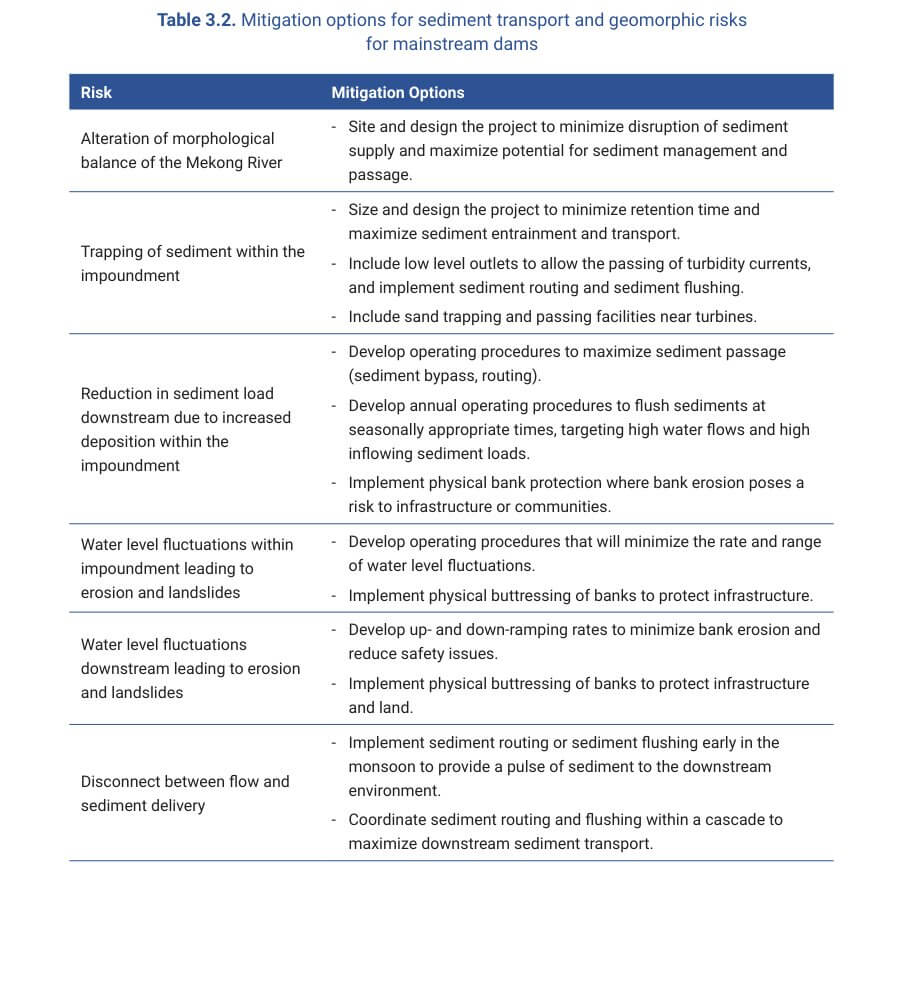
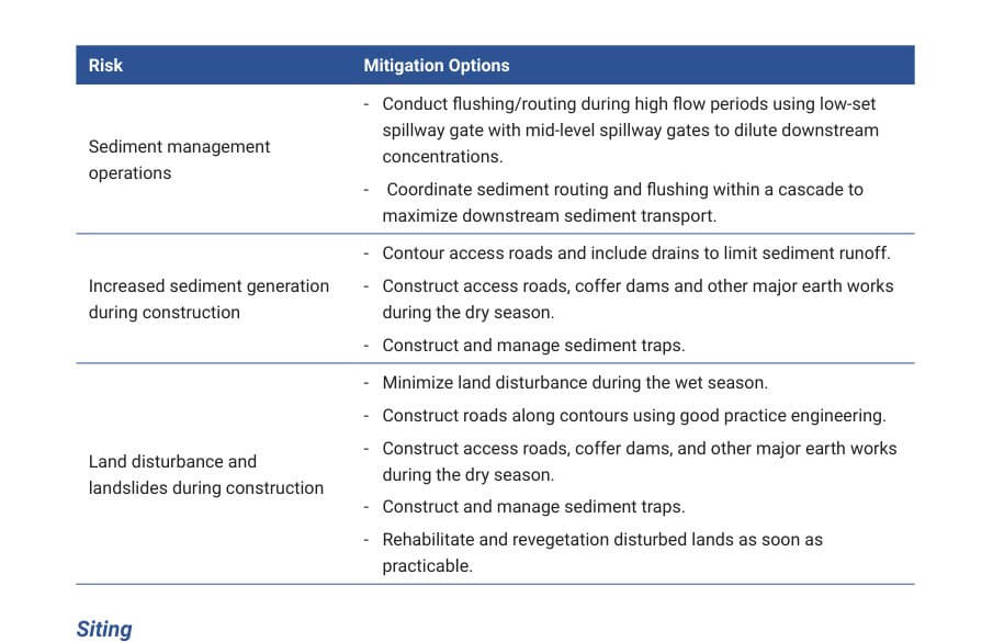
95. Mitigation options should be evaluated to determine which ones will best address identified risks. The modelling and monitoring results and project information should be used to evaluate the potential sediment transport and geomorphic risks associated with the project, and identify and optimize appropriate mitigation measures. Mitigation options should clearly address the identified risks relevant to the project. Mitigation options to address potential risks relating to mainstream dams are summarized in Table 3.2 . Not all risks will apply to every project, and there may be additional risks that require consideration. Additional information is provided in the following clauses.
Siting
96. Developers should consider alternative dam sites at the earliest possible stages of planning, with modelling used to assist the selection of sites whose natural attributes combined with the hydraulics of the river flow at the site best facilitate passage of sediment. The potential for sediment bypass channels should be included in this early planning phase.
97. Particular care should be taken to avoid sediment deposition that poses risks for the safe working of the flood passage capacity of the dam.
98. Dam layouts, including the location of the turbine intakes, low-level outlets and spillway gates should be planned to minimize deposition near intakes and maximize the potential for frequent sediment flushing.
Dam infrastructure
99. Low-head, small impoundment run-of-river projects will trap less sediment than dams with storage capacity because fine sediment is more readily held in suspension, and routing or flushing of fine and coarse sediment can be carried out more easily and efficiently.
100. Dams and intake structures should be designed to minimize the deposition and entrainment of sediment near the dam to ensure long-term safe operation. If applicable, sand passing facilities should be included near the turbines to allow episodic flushing of sediment from near turbine intakes or to facilitate sediment flushing in response to adaptive management.
101. Projects in which sediment routing or sediment flushing are the only mitigation options for passing sediment to the downstream environment should include large, low-level outlets to allow for sediment routing (pass-through) and drawdown for sediment flushing. Gates should have the following characteristics:
- The gates should be located at maximum depth within the impoundment to maximize potential for sediment flushing.
- The height of the sill at the base of the gates above the bed of the river should be minimized to reduce the volume of sediment required to be deposited prior to enabling discharge via the low-level outlets.
- Gates and flushing galleries or tunnels should be large enough to accommodate flows sufficient to entrain and transport coarse sand and gravel in suspension and prevent clogging.
- Mid-level gates (or spillways) should be included to allow dilution of the highly concentrated bottom waters that are released.
102. Fail-safe provisions, such as stop logs or additional gates, for dewatering the structures immediately upstream and immediately downstream of the bottom gates should be provided to enable cleanout in the event of blockage.
Sediment management and mitigation during construction
103. During the construction stage, sediment management should aim to:
- minimize runoff from the site, using appropriate construction methods and mitigation measures such as sediment traps. Revegetation of disturbed areas should be completed as soon as practicable;
- minimize the risk of landslides and land disturbance associated with the construction of infrastructure and access roads, including to transmission lines or ancillary services.
Sediment management and mitigation during operations
104. During the operation stage, sediment management should aim to:
- minimize sediment deposition within the impoundment or near infrastructure that can affect operations of the hydropower project;
- maintain a seasonal supply of sediment to the downstream environment, maintaining sediment loads and sediment grain-size characteristics similar to pre-dam conditions as much as practicable;
- manage the impoundment to promote the downstream transport of bedload; and
- minimize water quality and river morphology changes resulting from routing or flushing operations.
105. Targets for sediment management should include the following:
- The passage of sediment should be promoted during all flood events with low-level outlets opened in combination with mid-level flood gates.6
- At least 70% of the fine-sediment (grain size < 63 μm) entering an impoundment should be discharged on an annual basis to downstream of the dam. This is to maintain a supply of fine-sediment and nutrients to the downstream environment, including the Tonle Sap and delta. A target of 70% is considered an operationally feasible target that would provide downstream benefit.
106. Mitigation strategies, including operating rules where applicable, should be developed and included in the PNPCA reports to address the risks identified under Section 3.2 and achieve the targets listed in Clause 105. These strategies should include an adaptive management component demonstrating how operations could adapt to changing conditions. Strategies should also consider the potential for downstream environmental impact associated with the release of unnaturally high sediment loads and include precautions to minimize the degree and extent of downstream impacts. Where applicable, modelling should be used to determine the extent of downstream impacts and used to notify downstream countries. Sediment mitigation strategies should also aim to be compatible with fish migration mitigation strategies with respect to timing and execution (e.g. rate of drawdown), and minimize water quality impacts. Other possible sediment mitigation strategies are as follows:
- Sediment bypass: This involves diverting sediment-laden water into a channel or tunnel from the river channel upstream of the impoundment, bypassing the impoundment, and delivering the sediment to the channel below the dam. This approach transports both fine- and coarse-grained sediment, preserves continuity of sediment transport to downstream reaches, and avoids sedimentation problems in the impoundment. However, it is possible only in situations where the geometry of the river and impoundment are favourable.
- Sediment routing: This involves a seasonal draw-down of the impoundment to allow the passing of suspended sediment through the impoundment to avoid net sedimentation. Sediment routing should be carried out when sediment concentrations and sediment transport rates are high, such as early in the flood season. 6 As per clause 101, mid-level gates may also need to be operated simultaneously to dilute flushed sediments.
- Pressure flushing: This is based on opening the low-level outlets but not reducing the water level in the impoundment to pre-dam levels. This approach has limited effectiveness because it generally only removes sediments located near the dam wall; therefore, it is not an efficient method for removing large volumes of sediment from impoundments.
- Sediment flushing: This involves drawing down the impoundment and allowing accumulated sediments to be eroded and pass through low-level outlets into the downstream channel. As with sediment routing, the impoundment temporarily behaves like a reach of river, transporting sediments through the dam. Unlike sediment routing or bypassing sediment, flushing releases more concentrated sediment discharges over shorter time periods, thus changing the temporal pattern of sediment release. Flushing can only be carried out on impoundments that can be drawn down regularly, and is most effective when the low-level outlets are large and can pass sediment-transporting flows without creating backwater conditions. Sediment flushing is also effective at moving bedload material downstream within an impoundment. The timing and duration of sediment flushing should consider ecological considerations such as the timing of fish migration.
107. Operating rules related to sediment flushing should consider the following:
- Sediment flushing during base flow periods should be avoided in order to minimize downstream impacts associated with the release of very high turbidity levels and deposition of sediment that will remain in the channel for prolonged periods.
- A maximum downstream sediment target concentration should be established based on social and ecological considerations and sediment monitoring results. An initial guide is the natural (pre-Chinese dams) maximum sediment concentrations that occurred during the flood season.
- The sediment concentration of water released during flushing operations should be controlled and monitored to prevent negative impacts on downstream ecology. Monitoring locations should be guided by site-specific conditions, including the location of downstream settlements and land use as well as important habitats and ecosystems.
- The operating conditions associated with flushing (rate of drawdown, duration of drawdown, timing of flushing) should be guided by site-specific conditions, including sediment inflows, downstream safety, and ecological risks, and be consistent with and take into consideration fish and water quality management aims and strategies. Modelling runs of potential flushing regimes should be used to optimize sediment passage, and sediment flushing strategies should form an integral component of Cascade Joint Operating Rules.
- A communication strategy should be developed by the operator of individual projects to inform stakeholders of any atypical operations associated with sediment management. Where these operations have the potential for transboundary impacts downstream, the communication strategy should include communication with the downstream Member Countries.
Mechanical removal of sediment
108. Where hydraulic flushing is not possible, sediments accumulated in the impoundment can be removed mechanically by dredging or drawing down the impoundment and excavating dry. Dredging can be carried out using hydraulic suction driven by a pump, siphons, or mechanical clamshell or bucket ladder dredges. Key considerations include the location of suitable disposal areas nearby, distances and vertical uphill haul required, and the logistics of transferring sediment from the impoundment deposit to truck, or in some cases, slurry pipeline. Mechanical disturbance of sediment may also be implemented during sediment flushing to increase the mobilization of deposited material.
Management of geomorphic impacts downstream of dams
109. This Guidance includes the most practical approaches for mainstream dams. Other sediment and geomorphic approaches, such as re-regulation weirs, sediment traps, or sediment augmentation, may be applicable in some cases.
110. Downstream impacts need to be considered in a catchment context. Other activities that affect river geomorphology, such as aggregate extraction, should be managed in conjunction with hydropower operations to reduce synergistic impacts. This would be the responsibility of national agencies and not the developer.
111. The rate of erosion or deposition downstream of a dam may be reduced through implementation of Project-Specific Operating Rules that minimize the rate and limit the magnitude of water level changes (see Clause 70).
112. In place of, or in addition to, operating rules, river bank erosion control may be required at the expense of the operator to control bank erosion downstream of the project or along the shore of the impoundment.
Managing sediment in a cascade of dams
113. Sediment management based on the objectives identified in Clause 105 should be planned and coordinated between projects within a cascade of dams, ideally through Cascade Joint Operating Rules. This may be achieved through cooperation between developers, the host nation and, potentially, regional agencies (e.g. the MRCS) if required. Basic numerical modelling of the cascade should be used to guide management and minimize impacts within impoundments, and on the downstream environment. A description of how management of sediments will be coordinated should be included in the PNPCA documentation, taking into account the state of cascade-level analyses and development of Cascade Joint Operating Rules. In the absence of established rules, the developer should indicate how project-specific management measures have taken into consideration the need for coordinated sediment management within the cascade.
114. The Cascade Joint Operating Rules should include a communication mechanism between operators within a cascade and the Member Country to enhance the exchange of information and provide a system for informing the public of hydropower operations such as sediment flushing, similar to that described in 107. The communication strategy should include a mechanism for informing downstream Member Countries of any atypical (e.g. sediment flushing, routing) hydropower operations with potential transboundary impacts.
115. Plans for project monitoring of sediments and geomorphology should take into account the guidance in Clause 26. The PNPCA information should demonstrate that plans for sediment transport and geomorphology monitoring information to be collected during construction and operation will inform:
- developers’ needs regarding sediment management operations, and in particular related to sediment flushing;
- indicators that may signal a need for adaptive management responses to sediment or geomorphology related mitigation measures.
116. The monitoring programme for sediment transport and geomorphology at the construction and operation stage should recognize the site-specific characteristics of the project and aim to capture the following aspects where applicable.
- Measurement of sediment inflows and outflows from the impoundment area should be undertaken, including the determination of sediment grain size. The same monitoring parameters and monitoring frequency as described in Section 3.3 are recommended. Other than within the impoundment, monitoring locations should be the same as pre-project sites, and should include upstream of the backwater to quantify inflow and downstream of the dam to quantify outflows.
- Survey the bathymetry within the impoundment at a resolution and frequency sufficient to quantify the rates of sediment accumulation or scour.
- Survey cross-sections and bathymetry at the upstream extent of the backwater, at a resolution and frequency to determine changes that might affect navigation.
- Cross-sections of the river downstream of the dam should be surveyed annually for the first five years of operations and every two years thereafter. A downstream monitoring plan should be developed that takes account of the location of the project, the location of other projects, and proximity to alluvial river reaches. Monitoring should extend through the project-affected reach, 7 or to the backwater of the next project downstream, with cross-sections spaced at appropriate 8 intervals and targeting alluvial reaches. Crosssections should extend above the maximum water level height of the river;
- River banks along the new flood level line of the impoundment should be monitored to establish rates of erosion.
- Site-specific attributes of the monitoring programme should account for the position of the project relative to other mainstream and tributary projects and the proximity of tributaries and national borders.
117. Adaptive management measures should be guided by monitoring results, in accordance with Clause 27. These measures include, inter alia, the frequency, timing, and duration of sediment routing or flushing, and ramp-down rates to minimize downstream bank erosion. Monitoring results can also guide the implementation and management of downstream infrastructure to minimize bank erosion, such as bank armouring or use of groynes, if required. Development of the project monitoring programme should consider how well it will inform whether the objectives guiding these different aspects of operations are being met. 7 See Clause 20. 8 The distance between cross-sections monitored will depend on the river morphology and the presence of alluvia reaches.
Use the interactive database below to search, filter, and download formal guidance documents, technical papers, and checklists for this topic.
Use the interactive database below to search, filter, and download formal guidance documents, technical papers, and checklists for this topic.
| Title | Date | Type | Size | Link |
|---|