Hydrology and Hydraulics
This topic addresses how a mainstream dam changes the river's flow regime, and how design and operation can keep those changes within acceptable limits for downstream users and ecosystems.
Download this section (PDF)
Key objectives
- Minimise changes to the natural mainstream flow regime, operating as far as practicable in run-of-river mode.
- Avoid rapid, artificial water-level fluctuations downstream (sub-daily peaking) that endanger people, riverbanks and aquatic life.
- Maintain flow continuity and dry-season flows, and allow the safe passage of floods.
What the guidance addresses
The guidance covers flow-regime maintenance, hydro-peaking limits, reservoir operating rules, spillway and outlet capacity, and the monitoring of water levels and discharge at agreed locations.
34. The objectives of this guidance on hydrology and hydraulics are to ensure that:
- project developers have a detailed understanding of the hydrological resource availability and reliability to inform project planning, design, construction, and operations, taking into account present and potential future trends (e.g. alternative climate change scenarios);
- mitigation measures and cascade or project operating rules dependent on hydrology and hydraulics are underpinned by sound hydrological and hydraulic assessments; and
- mainstream developments are able to meet the objectives of the Procedures for Maintenance of Flows on the Mainstream (PMFM) (see MRC, 2006) and the Procedures for Water Use Monitoring (PWUM) (see MRC, 2003b) within the Mekong Agreement framework, which require that every effort is taken to manage and maintain a minimum flow, and to minimize rapid changes in key river flow indicators to avoid harm to downstream users and the ecology.
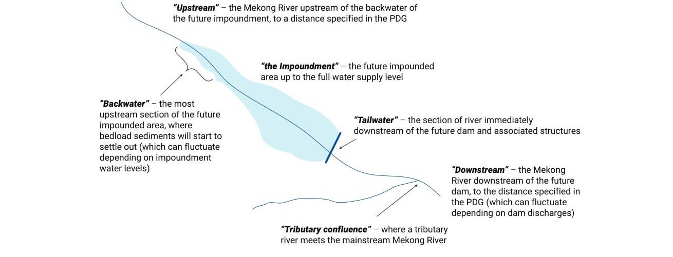
35. Figure 2.1 shows the important locations of hydrology and hydraulic change that occur due to a mainstream project, and establishes some common terminology that will be used throughout this Guidance.
36. Because all parts of the flow regime play a role in sustaining the riverine ecosystem, altering any part can translate into physical and biological changes. The more the flow, sediment, navigability, or water quality regimes are changed, the more ecosystem and socio-economic responses will occur.
37. The main impacts of hydropower projects in the Mekong Basin related to water flows are:
- altered flow regimes in the downstream river due to the project operations, which may have large-scale influences, depending on the attenuation of these impacts downstream;
- impoundment and backwater effects upstream of the dam. Direct impacts include permanently inundated areas, increased water depth, and reduced water velocities;
- loss of connectivity. Longitudinal connectivity along the Mekong River is interrupted because of the barrier effect of the dam, and lateral connectivity between main channel and floodplains or secondary channels can be diminished because of changes in flood hydraulics;
- dam safety related impacts, for both temporary structures during the construction stage and permanent structures during the operations stage (addressed in Section 7).
38. Risks arising from changes in hydrology and hydraulics should be comprehensively assessed. Table 2.1 shows the potential consequences of changes to hydrology and hydraulics on various focal areas covered in this Guidance. Mainstream dams are proposed to be operated in run-of-river mode, meaning that inflows pass quickly through the impoundment and are discharged with very little water retention capability. The key risks for environmental and socio-economic receptors of impact, therefore, mainly arise due to daily and short-term flow changes to the downstream river with hydropower operations, and from the impoundment of water behind the dam.
Table 2.1. Risks arising from changes in hydrology and hydraulics
| Risks | Focal area of impact |
|---|---|
| Risks arising due to daily or short-term changes in downstream flows | |
| Riverbank erosion, sediment grain-size changes | Sediments and Geomorphology (see Section 3) |
| Fluctuating water quality, with variable temperature and nutrients; altered concentration of downstream discharges | Water Quality (see Section 4) |
| Flow velocity changes causing drift or stranding; habitat impacts and loss; temperature changes causing stress and offset of migration triggers | Aquatic Ecology (see Section 5) and Fish (see Section 6) |
| Fluctuating water flows and water levels, transient impacts on infrastructure, such as in the tailrace due to load rejection, spillway gate operation, and dam safety risks due to extreme floods or maximum hydraulic loads | Project Infrastructure and Dam Safety (see Section 7) |
| Public safety and navigation-related risks with water levels in the tailrace and downstream river; flood risk in the downstream river due to sudden releases from the dam during floods (e.g. lowering operation level for flood protection, or for flushing) | Socio-Economics including Navigation (see Section 8) and Public Safety |
| Risks arising due to river impoundment | |
| Deposition of sediments in the impoundment; bank instability | Sediments and Geomorphology (see Section 3) |
| Stratification; temperature changes; nutrient trapping. | Water Quality (see Section 4) |
| Drowning and sedimentation of deep pools; habitat loss due to inundation; deposition of drifting eggs/larvae due to low flow velocities | Aquatic Ecology (see Section 5) and Fish (see Section 6) |
| Backwater impacts due to inundation or backwater fluctuations near areas of social importance; increasing flood levels in time upstream; navigation risks due to submerged rocks | Socio-Economics including Navigation (see Section 8) and Public Safety |
39. Cumulative hydrological impacts arise due to multiple hydropower developments, in particular from projects with the ability to store water and make unseasonal releases. The following conditions may affect project design:
- When comparing the historical flow series to flows in recent years, it is evident that flows on an annual/seasonal scale are noticeably impacted by the existing storage dams in the Upper Mekong (the Lancang) and by tributary schemes (MRC, 2018b).
- Flow releases from upper dams can lead to changed flow and water level fluctuations that affect the operations of the lower dams. For instance, an impoundment draw-down and sediment flushing operation at an upper dam can lead to an accumulation of flood waves created by the sudden gate opening of each consecutive dam.
- A new development cannot be expected to mitigate risks arising from existing projects, but the developer should recognize and incorporate these potential risks into the proposal. For example, it should be demonstrated that the project can handle a major flood created by a Chinese dam opening its gates.
40. Risks for the focal areas covered in this Guidance arise from changes in hydrology and hydraulics due to hydropower operations. In addition, naturally occurring droughts and floods may exacerbate impacts arising from dams and should be considered in any scenario evaluations for risk and how they can be managed.
41. The information submitted for the PNPCA process should demonstrate that the planning and design of the hydropower project is based on a good understanding of the hydrological resource availability and variability in the short and long term, as well as the hydraulic characteristics in the river near the dam infrastructure. Misunderstanding of the magnitude, timing, variability and extremes of water inflow patterns can present significant infrastructure safety risks.
42. Quantification of pre-project conditions and quantitative identification of potential changes for hydrology and hydraulics should be based on a combined monitoring and modelling approach. The approach should include:
- monitoring of water levels and discharges at specific sites;
- hydrological modelling to establish time-dependent hydrological conditions at locations in between monitoring sites;
- hydraulic numerical modelling to quantify flow conditions in the impoundment, in the impoundment backwater, near the dam infrastructure, the downstream river, and at major tributary confluences; and
- combined, these approaches should be used to quantify hydrologic and hydraulic parameters and variability over a range of time-scales (hourly to annual) and spatial scales to provide an accurate understanding of the conditions at the project site.
43. The spatial extent of monitoring and modelling should be in accordance with Clause 20. The developer should show the limit of influence and how it was chosen, and the type and degree of change should be shown at the perimeter of the modelling. This analysis underpins considerations for many other disciplines and areas of risk.
Guidance for monitoring
44. The monitoring approach for evaluation of hydrology and hydraulics should form the basis of an overall monitoring framework to which topic-specific monitoring (e.g. for water quality, sediments, etc.) can be fit. This approach should be shown in the PNPCA information to be sufficient to inform design, to support modelling for impact prediction, and to help with later impact evaluation. Clause 23 provides basic principles to guide the design of the overall monitoring network. The following clauses 45 to 54 can be used as a guide and varied to suit project-specific conditions, as per Clause 23.
45. A network of hydrological monitoring stations should be developed to support the project over its full life cycle. Data sources in this network may include those managed by national agencies accessible to the project. The number and location of monitoring sites should be determined based on an evaluation of monitoring data needs and existing monitoring stations (including determination of data accessibility and quality). The MRC hydrometric sites upstream and downstream of the project should be included in this network to provide long-term trends.
46. Data to be collected for pre-project hydrological analyses should include:
- Climatic data – rainfall, temperature, evaporation, etc.;
- Topographic data – slopes, river length, topography/bathymetry;
- Stream flow data – water level, discharge, floods;
- Groundwater data – infiltration, seepage if applicable.
47. Monitoring site locations should be carried out:
- at the closest MRC monitoring site located upstream of the project, or if relevant, downstream of an existing upstream mainstream hydropower project, for connection of the basin-wide hydrology and for deriving the long-term (>10 year) records;
- upstream of the future impoundment (upstream of the backwater section) to inform on inflow conditions over the long term;
- directly upstream of the future hydropower dam (within the future impoundment);
- in the future hydropower tailwater (downstream of water release infrastructure); and
- at suitable locations downstream of the dam over the distance where there is a demonstrated significant effect of the project (as per Clause 20, at intervals that reflect the reach-specific nature of the river, and accounting for locations of tributaries and locations of downstream projects).
48. The hydrological monitoring network should include upstream tributary monitoring stations that contribute to impoundment inflows. Data from tributaries directly downstream of the future dam should be included where the tributary flows may impact on the tailwater through backwater influences (e.g. cross-currents that may affect navigation towards the shipping locks).
49. Water level time series data for planning/design, construction, and operation should be measured at fixed and temporary gauging stations that are located in stable river reaches and referenced to mean sea level (MSL). These data should be hourly, particularly in reaches influenced by upstream hydropower schemes or downstream of the construction site to be able to register short-term fluctuations.
50. Discharge time series data for planning/design, construction, and operation should involve repeated measurements taken at different discharge levels (low flows to high flows) at the water level monitoring sites to establish rating curves. Rating curves should enable quantification of discharges for periods in between surveys. Correction for hysteresis effects and backwater influences is recommended. Discharge time series data should also provide flow velocity and depth measurements that can inform sediment and water quality modelling, as well as support calibration of hydraulic models.
51. The duration of hydrological data collection should enable coverage of the full annual cycle with low and high flows, as well as provide insight into inter-annual variability, which is substantial in the Mekong and should be factored into project design. The project-specific field data should be collected for a period of at least one year. These data should be collected prior to the finalization and submission of PNPCA documentation, and explained in light of longer-term trends by having the monitoring network include one or more long-term monitoring sites. The field data collection should continue through the pre-project period to capture more of the inter-annual variability and be used to inform detailed design. The length of flow record should allow derivation of a time series of at least ten years for planning and design purposes. The longer the time series of inflows, the higher the confidence level and the better the understanding of hydrological risk.
52. It is recommended to follow the guidelines on monitoring and quality management of hydrological data provided by the World Meteorological Organization (WMO, 2008). Monitoring data should be validated as being of good quality, and checked for consistency to identify gaps and non-conformances with typical hydrological patterns.
53. An important resource for long-term meteorological and hydrological monitoring data for the Mekong mainstream is the MRC hydrology database, along with the existing national meteorological and hydrological databases.
54. The implementation of a telemetry network for stream gauges may be considered, especially given the non-rainfall dependence of inflow from China. A further extension to include rainfall radar and other sources of information, and inclusion of a forecasting module may improve the lead time for prediction of inflows significantly.
Guidance for modelling and analyses
55. Hydrological and hydraulic models should be used to determine specific conditions between the monitoring sites and at the dam infrastructure, and to forecast future conditions with and without the proposed dam. Operation of upstream and downstream dams may also need to be modelled and analysed. Clause 24 provides some basic considerations related to modelling and analyses. The following clauses 56 to 60 can be used as a guide and varied to suit project-specific conditions.
56. Hydrological modelling should be used to assess changes to inflows due to upstream and downstream projects. Hydrological models should be well-calibrated with multiple, short- and long-term gauging stations over at least a 12-month period. The Decision Support Framework (DSF) of the MRC provides validated and calibrated hydrological models that may be applied for this purpose.
57. Suitable fully dynamic hydraulic modelling should be used together with the hydrological models to predict and assess water level fluctuations, discharges, and flow velocities due to the operation of the hydropower project. The following considerations should be taken into account:
- Hydraulic models should be calibrated and verified using all available monitoring data. The calibration should be carried out for reproducing the water levels and fluctuations correctly, and the model should also be able to reproduce flow velocities along the impoundment and the river.
- Modelling for sediment and geomorphology, water quality, aquatic ecology, and dam break flows should be integrated with the hydrological and hydraulic modelling.
- Dam break simulations should determine the extent of inundations and hazards in the downstream reach (see Section 7, Dam Safety).
- Detailed hydraulic models may be used to assess the complex flow at the inlets, navigation locks, access to the locks, stilling basins, and fish passages.
- Physical models may be needed to assess certain details of three-dimensional turbulent flows near the dam infrastructure. It should be demonstrated that proper scaling has been applied.
58. The analyses for hydrology and hydraulics should consider:
- a range of scenarios including very dry (5% probability of exceedance), average and very wet (5% probability of exceedance) years;
- current and potential future climate conditions (including climate change and sea level rise);
- the start of operation of large Chinese storage dams in the Lancang cascade (notably Xiaowan and Nuozhadu hydropower projects) and their impacts on seasonal flows over the past years;3
- as far as possible, long-term future developments in the river basin upstream and downstream of the project;
- flow conditions with and without the project, including upstream developments (e.g. for modified flow regimes) and downstream developments (e.g. for modified tailwater levels);
- flow conditions and flow alterations during construction and operation;
- gradual geomorphologic changes and their impacts on water levels, such as backwater sedimentation processes or decreasing flood levels due to downstream channel incision.
3 The MRC may provide information arising from model studies carried out as part of basin scale assessment.
59. Assessment results should be presented in the documentation for the PNPCA review for all relevant indicators of significance that reflect the risks and vulnerabilities of the system due to flow alterations. The following should be presented:
- Basic hydrologic and hydraulic information for PNCPA submission should include: impoundment volumes and residence time; inflows; water velocities within the impoundment; proposed discharge patterns associated with hydropower and gate operations; and rates of water level change in the impoundment and downstream. More specific guidance is provided in other sections of this Guidance relating to topicspecific information needs for hydrologic and hydraulic information.
- The MRC Indicator Framework and the Hydropower Mitigation Guidelines (MRC, 2018a) can be referred to for further guidance in selection of relevant indicators, accounting for the linkages between themes. Reference can be made to recent relevant MRC studies and relevant literature for more detailed indicator frameworks.
60. The analyses of changes, impacts and mitigation options for hydrology and hydraulics should clearly identify the residual impacts and document where these will occur in the river, in line with Clauses 7 and 24.
61. Mitigation options should be evaluated to determine which ones will best address identified risks. The modelling and monitoring results should be used to help identify the underlying hydrological and hydraulics changes that have consequences for environmental and socio-economic values, and to identify and optimize appropriate mitigation measures. Mitigation measures should clearly address identified risks. Table 2.2 identifies mitigation measures that can address the core sources of impact relating to hydrology and hydraulics.
Table 2.2. Mitigation options to address hydrological and hydraulic changes
| Hydrological or Hydraulic Changes | Mitigation Options |
|---|---|
| Daily or short-term alterations in the downstream flows |
|
| River impoundments |
|
Planning and design stages
62. Siting of the hydropower project at the earliest stages of planning can help to minimize impacts to sensitive areas from either inundation or downstream flow fluctuations, such as floodplains with high ecological value or major urban areas. Water level fluctuations may be most severe immediately downstream of the project, but reduce further downstream due to flow attenuation.
63. Project-Specific Operating Rules, or at least their principles , should be established at the feasibility design stage and be included in the project economic/financial evaluation. Operating rules should take into account:
- any Cascade Joint Operating Rules aimed at ensuring harmonized operations within a cascade
- environmental flow objectives downstream of the project;
- any need for maintenance of minimum flows downstream in relation to occasional interruptions of power station operations;
- ramping rates as per Clause 70; and
- management of downstream risks when turning on or off multiple turbines over a short period during the dry season.
64. Dam infrastructure, including turbines, bypass valves, gated outlets, and the gated spillway, should:
- be designed to allow passage of a wide range of flows (including extreme floods); and
- have sufficient capabilities for up-ramping and down-ramping during possible (partial) emptying or filling of the impoundment, for instance due to flushing operations, maintenance, calamities with rapid shutdown, electrical or mechanical faults, etc.
65. The impact of possible future development of additional dams in the cascade should be addressed in the design of the infrastructure4 (e.g. to allow passage of flow pulses from upstream operations) and with regard to the downstream flows.
Construction stage
66. The developer should demonstrate that issues in relation to flow regimes downstream of project infrastructure during project construction and impoundment filling have been identified and assessed, and monitoring enables identification of any emerging issues.
Operation stage
67. Cascade Joint Operating Rules should be established by one or more Member Countries in which the projects are located, together with project developers and importing countries. Member Countries, that may be impacted by the operations of the cascade, should be consulted. The Cascade Operating Rules should provide a framework for Project-Specific Operating Rules for all projects within the cascade, as per Clauses 3 and 29.
68. Cascade Joint Operating Rules should reflect the important areas that require coordination to avoid cumulative impacts. These may include, for example: common flood management rules governing draw-down and opening of gates; coordination of maintenance periods; common rules for navigation lock operation; and coordinated timing for sediment flushing actions.
4 The information on these future developments may need to be sourced from the host Member Country or the MRC as part of national or regional planning.
69. Project-Specific Operating Rules should be fully aligned with Cascade Joint Operating Rules, but may also have more specific requirements taking into account local conditions and needs. These may include, for example, specifications on rates of downstream water level change, or flow quantity and velocity requirements for operation of the fish passage.
70. Water level ramping rates for the impoundment and downstream releases should seek to minimize identified risks, which will be project- and discipline-specific. Hydraulic modelling should be used to assist in identifying risks that are affected by fast draw-down or rampup rates, and to test the benefits of ramping rates for mitigation. Some guidance relating to the influence of ramping rates for specific disciplines can be found in the Hydropower Mitigation Guidelines (MRC, 2018a).
71. Plans for project monitoring of hydrology and hydraulics should take into account the guidance in Clause 26. The PNPCA information should demonstrate that plans for hydrology and hydraulics monitoring information to be collected during construction and operation will inform:
- developers’ needs regarding operations, including any indicators that may be expressed in the Project-Specific Operating Rules or Cascade Joint Operating Rules; and
- indicators relating to, or drawing on, data for water levels and flows, for any of the disciplines covered in Sections 3 to 9, that may signal a need for adaptive management responses.
72. The monitoring programme described in Section 2.3 should be continued during the construction and operation stages, and adapted where needed to better inform the information requirements for management during the construction and operation stage and to meet the needs of Clause 27.
73. Examples of water level and flow related aspects of project operations that may be able to be adaptively managed include minimum flow releases, ramping rates, impoundment water levels and fluctuations, flood rules, and gate operations. Plans for the project monitoring programme should consider how well it will be able to inform whether the objectives guiding these different aspects of operations are being met.
Use the interactive database below to search, filter, and download formal guidance documents, technical papers, and checklists for this topic.
Use the interactive database below to search, filter, and download formal guidance documents, technical papers, and checklists for this topic.
| Title | Date | Type | Size | Link |
|---|